Damaging Tornado Strikes Westmoreland County, PA
For the first time since December 2006, a tornado has touched down in Westmoreland County, PA. This was a very impressive storm which, unfortunately, caused significant damage in Hempfield Township – including the Fort Allen neighborhood which was damaged by the December ’06 twister. This very severe storm began to intensify quickly as it entered western Westmoreland County around 4:25PM on March 23, 2011. The National Weather Service in Pittsburgh observed a tornado vortex signature on Doppler radar at 4:29PM and, correspondingly, issued a tornado warning for central Westmoreland County eight minutes later at 4:37PM.
Some have argued that this was an abnormally long delay between observing the tornado on radar and issuing a warning. Do note a few items in this case, however. First and foremost, the Pittsburgh area does not see tornadic conditions all that often. While I’m sure there have been more (false alarm) tornado warnings issued since 2002, there have only been 7 dates when tornadoes were confirmed in Southwestern Pennsylvania, according to the Tribune-Review. Thus, one could argue that NWS meteorologists in the Pittsburgh office may not be as “experienced” in issuing Tornado Warnings. They also may be a more conservative office, wanting to attempt to minimize the number of false positive tornado warnings. There was also some precedence for severe weather events in Westmoreland County on Wednesday, as the entire region had been under a Tornado Watch since 1:15PM and the county had been severe thunderstorm-warned for a solid 20+ minutes before the tornado warning was issued. Finally, it is important to note that the worst of the damage occurred in Hempfield Township, right where the green arrows are in the below picture (Figure 1). The strongest radar echoes (colors on the radar) were still a few miles west of the area of greatest damage at 4:42PM, and in fact, the preliminary Storm Prediction Center tornado report was not until 4:45PM. This means residents of the Fort Allen area (and surrounding communities near Hempfield High School) had approximately 10 minutes of notice from the Tornado Warning and even more time from the Severe Thunderstorm Warning. Finally, the warnings obviously did their jobs regardless of timing, as no serious injuries were reported.
Figure 1: 4:42 PM Reflectivity and Velocity Radar images (dead image link)
Four minutes later, at 4:46PM, extremely strong rotation was reported on the velocity mode of the Doppler radar. (You can read more about how velocity mode works here, but for now, know that strong values of red and green right beside each other [known as a “couplet”] are very strong indicators of a tornado.) The center of circulation, as represented by the green arrows on the radar image below (Figure 2), appears directly over west-central Hempfield Township area, right near Hempfield Area High School, which sustained significant damage in the storm – including roof damage to the auditorium and damage to the athletic fields. The numbers on the radar image correspond to the figure numbers of the other images listed below and their approximate locations. This should help to frame exactly what the tornado looked like around 4:50PM. Figure 3 really speaks to me about the potential strength of the tornado, as the twister appears to be taking on a classic “stovepipe” shape.
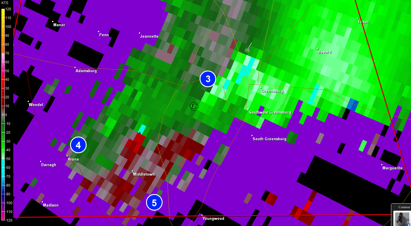
Figure 2: 4:42 PM Velocity mode Radar image with labels
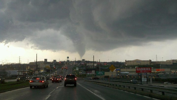
Figure 3: A funnel cloud is seen over Route 30 West in Hempfield Township
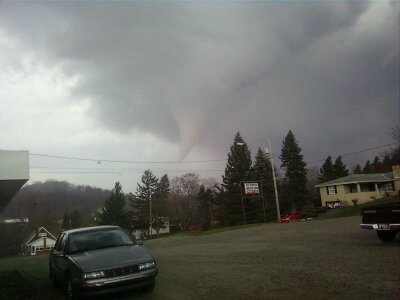
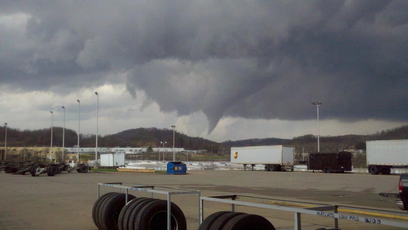
Figure 4 (left): Funnel cloud observed from Arona, PA; Figure 5 (right): Funnel cloud observed at the UPS facility in New Stanton, PA
There were a few other very interesting observations from this storm. The first of which was the massive amount of large to “giant” hail that fell during the storm. There are numerous reports of hail at least golfball sized, causing damage to many vehicles. I have seen hundreds of photos of the hail, some of which were actually approaching baseball-sized. Figure 6 below was taken by my brother and shows the interesting cross-section of a hailstone that I’d approximate is about 1.25″ in diameter. For more details on the countless hail reports, check out the Storm Prediction Center Storm Reports page. Finally, it is interesting to note that Mike Smith, founder of WeatherData Services Inc, actually blogged about the hail from this storm as it was occurring, explaining the very strange occurrence of a “hail spike” on radar as the storm moved into Somerset County.
One last radar image I’d like to share is a not-so-commonly seen view of radar (see Figure 7): 3D radar! This radar image enables meteorologists to get a vertical view of a storm , somewhat like an MRI a doctor might have performed on your leg to “see inside” it. As stated on the image, this storm was a “Classic Supercell” – another example of a term you never hear in conjunction with the location Greensburg, Pennsylvania! You can see both the mesocyclone complex on the back edge of the storm (as labeled) as well as the hail core directly in front of it. To be honest, I never imagined I’d be looking at a radar image like this over top my hometown!
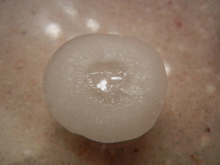
Figure 6: A cutaway view of hail, approximately 1-1.25" in diameter
Figure 7: A 3D radar view of the supercell over Greensburg, PA at 4:50 PM (dead image link, maybe someday I'll run the volumetric data and restore this)
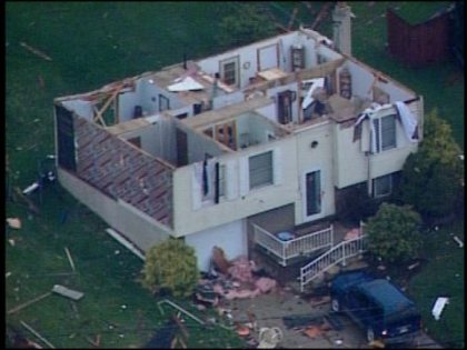
As noted earlier, this storm did cause significant damage to several dozen homes in central Hempfield Township and also the to the Hempfield Area High School. Many photographs of the damage show roofs partially or completely missing. Some buildings also sustained damage to exterior walls, including the dramatic photo shown above (courtesy of KDKA-TV). According to WTAE.com, this storm has been ranked by the National Weather Service as an EF2 (or “strong” tornado). The tornado was also observed to be about 300 yards at its widest point. Based on damage I have seen, I predict this storm will be rated, at a minimum, a strong EF1 tornado, but more than likely an EF2 tornado. I will update this story with the official results when they are made available.
Wednesday’s storm was easily the worst storm to strike Westmoreland County since at least June 1998 when a significant tornado outbreak occurred across western PA. Although I was watching from the Joel Myers Weather Center at Penn State, I can still say that I have never seen a storm this severe in Westmoreland County. The damage is simply incredible. For one final look, please check out the videos posted below.
Sources
Data for this article came from many readily-available sources including WTAE.com, KDKA-TV, and the Tribune Review, as well as the National Weather Service. The radar images (Figures 1, 2 and 7) come courtesy of Texas Storm Chasers, while the storm damage photos (Figures 3-5) come from WTAE.com’s uLocal member-upload site and Facebook page.
For more details on this storm check out the Tribune-Review article, KDKA article and videos, and WTAE article.
Videos
Update: As of 4:00PM on Thursday, March 24, the National Weather Service in Pittsburgh has confirmed the tornado in Westmoreland County as an EF2, or “strong tornado”. More details on the tornado track may still be forthcoming.